Someone marked “north” wrong on the map so it took 400 years until someone discovered the ancient civilization of Etzanoa near Ark City, Kansas. Once the map was turned a quarter of a turn to the right and West replaced North, it wasn’t long before archaeologists discovered it.
After the Spanish conquistador, Coronado wandered up through southwest Kansas in 1541 looking for Quivira and the seven cities of gold, another conquistador named Onate (Oh-naw-tay) wandered along the southern route in 1601. Hugging the northern part of what is now Oklahoma, he came to the confluence of the Arkansas (pronounced Arkansas, not Arkansaw) and Walnut Rivers around the present day Arkansas City. Along the way, he met up with the Escanjaques tribe, but passed by them when he realized they were not the seven cities of gold.
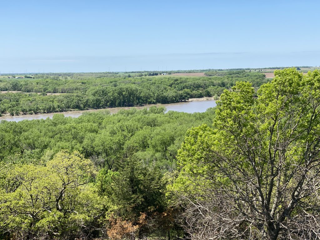
Reaching the confluence of the rivers, he and his entourage camped on a sand bar which you can spot easily from a high point north of the rivers where Camp Horizon now sits. Perched on that pinnacle that day, watching Onate and his more than 700 horses which had yet be be introduced to the area, was a scout for another tribe, the Etzanoans.Upon the report that strange men were camped on the sand bar, the Etzanoan chief and one of his right-hand men crossed the river to meet Onate. The conquistador was friendly, gave gifts to the two men and fed them.

Nervous about what the chief might do when he went back to his tribe, Onate convinced the two men to stay the night.Well, that totally freaked out the Etzanoans. Apparently the chief was not allowed to text the tribe to let them know he was OK, LOL. I suppose smoke signals were a form of texting, but he wasn’t allowed to do that either. Fearful that bad things had happened and were going to happen, the Etzanoans skedaddled north. All 20,000 of them. That must have been like traffic in Los Angeles on a Friday after work.
The next day, the chief led Onate and his group across the river and up on a ridge that overlooked a valley covered with grass. In those days, there was not the abundance of trees like today because of prairie fires and the massive millions of bison that coursed through an area eating everything they could.
A bit further north, they began to encounter ther village of grass huts which Onate’s men counted and came up with the number of 20,000 plus or minus a couple of Etzanoans. Later, archaeologists would claim this was the second largest civilization on the North American continent. Someone convince Onate that the cities of gold lay about 43 days travel in a different direction so he packed his bags and headed back south along that same ridge overlooking that valley of grass that seemed to go on for miles.
Only it didn’t because in that valley, was a deep ravine where 1,500 Escanjaques lay in wait, ready to attack. They wanted the horses. Onate was flummoxed when he saw the 1,500 warriors seemingly pop up out of the grass. The average height of a person was 4’9”. They attacked with bows, arrows, spears but Onate had a cannon. He loaded it up with canisters of metal and stone fragments and blasted away at the Escanjaques.

This was totally new to them and destroyed many lives, but they soon figured out it took Onate’s men eight minutes to reload and fire so they’d rush while they were reloading. The fight went on for five hours and was considered a draw and they let Onate leave.
Onate captured three people and took them back to Mexico. They interviewed one captive, Miguel, trying to understand the civilization. He also drew a map of the rivers and the location of Etzanoan village.

That interview, or interrogatory, is 99 pages long and historians and archaeologists have known that Etzanoans existed, but couldn’t find them. The grass huts were long gone and, since the tribe didn’t use stone for construction, there was little evidence to be found. If they could just find the field where that battle took place, they could find Etzanoans.
Fast forward to 2015 when one archaeologist, upon re-reading the interrogatory, came upon a phrase where Miguel described one structure laying “west” of another structure. She compared it to the map and it made no sense.Then she turned the map a quarter of a turn to the right which replaced N with W.
Archaeologists put a plan in place, using volunteers with metal detectors, searching for some metal fragments from the battle. Finally, a high school student dug up a musket ball.

All it took was finding true north to unlock a 400 year old mystery. That lesson is not lost on me. I wonder about myself, and others, what happens when we lose our true north? As Mark Twain said, “The happiest two days of your life are the day you are born and the day you discover why.” It seems like finding our true north is finding our “why”.
What’s your true north?
****
You can read more about this amazing story on the website. You can also be a volunteer archaeologist this July and search for more evidence. https://etzanoa.com/etzanoa/. If you’d like a tour, they are conducted out of the Cherokee Strip Museum in Ark City.
Thanks to the Frederick Remington Historical Society for arranging this tour. You can follow their Facebook page: https://www.facebook.com/Frederic-Remington-Area-Historical-Society-103139068674184

